World Map Game: Countries, Capitals and Continents
Star Charts is a free world map game for countries, capitals and continents, grades 3-6, played in a web browser on a desktop or laptop, with no account, no sign-in and nothing to install. One click per continent. Star Charts opens a navigation chart of the world with only those countries on it as stars, and the order line names a place: a country, a capital city, a continent or a landmark. The student steers the ship to the right star before the fuel runs out. Miss one and the chart lights the right country and holds the fact on the order line (LIMA — PERU), then asks it again a few orders later.
Pick a continent, press play
North America (8 countries)
Canada, the United States, Mexico, Central America and the Caribbean.
Canada, United States, Mexico, Cuba, Jamaica, Guatemala, Costa Rica, Panama
South America (10 countries)
Every country on the continent except Guyana, Suriname and French Guiana.
Brazil, Argentina, Chile, Peru, Colombia, Venezuela, Bolivia, Ecuador, Uruguay, Paraguay
Europe (17 countries)
Western, northern and eastern Europe. Russia is on the Asia chart (see the questions below).
United Kingdom, Ireland, France, Spain, Portugal, Germany, Italy, Greece, Norway, Sweden, Finland, Poland, Netherlands, Switzerland, Austria, Ukraine, Iceland
Africa (14 countries)
North, west, east and southern Africa, plus Madagascar.
Egypt, Morocco, Algeria, Libya, Sudan, Nigeria, Ghana, Senegal, Ethiopia, Kenya, Tanzania, Zimbabwe, South Africa, Madagascar
Asia (21 countries)
East, south, southeast and western Asia, plus Russia, Turkey and Kazakhstan.
Russia, China, India, Japan, South Korea, Mongolia, Thailand, Vietnam, Malaysia, Indonesia, Philippines, Saudi Arabia, Iran, Iraq, Turkey, Israel, Pakistan, Nepal, Bangladesh, Kazakhstan, Sri Lanka
Oceania (4 countries)
Australia, New Zealand, Papua New Guinea and Fiji. A short chart: good for a first try.
Australia, New Zealand, Papua New Guinea, Fiji
Or a whole unit
Continents of the world
Every chart, one question: tap any country in the continent named. Antarctica and the oceans are not in the game, so this practises the six inhabited continents.
Play this setEuropean capitals
Seventeen European capitals and no names on the map: Paris to France, Reykjavik to Iceland.
Play this setFamous landmarks
The Pyramids of Giza, Machu Picchu, the Great Wall: which country is each one in?
Play this set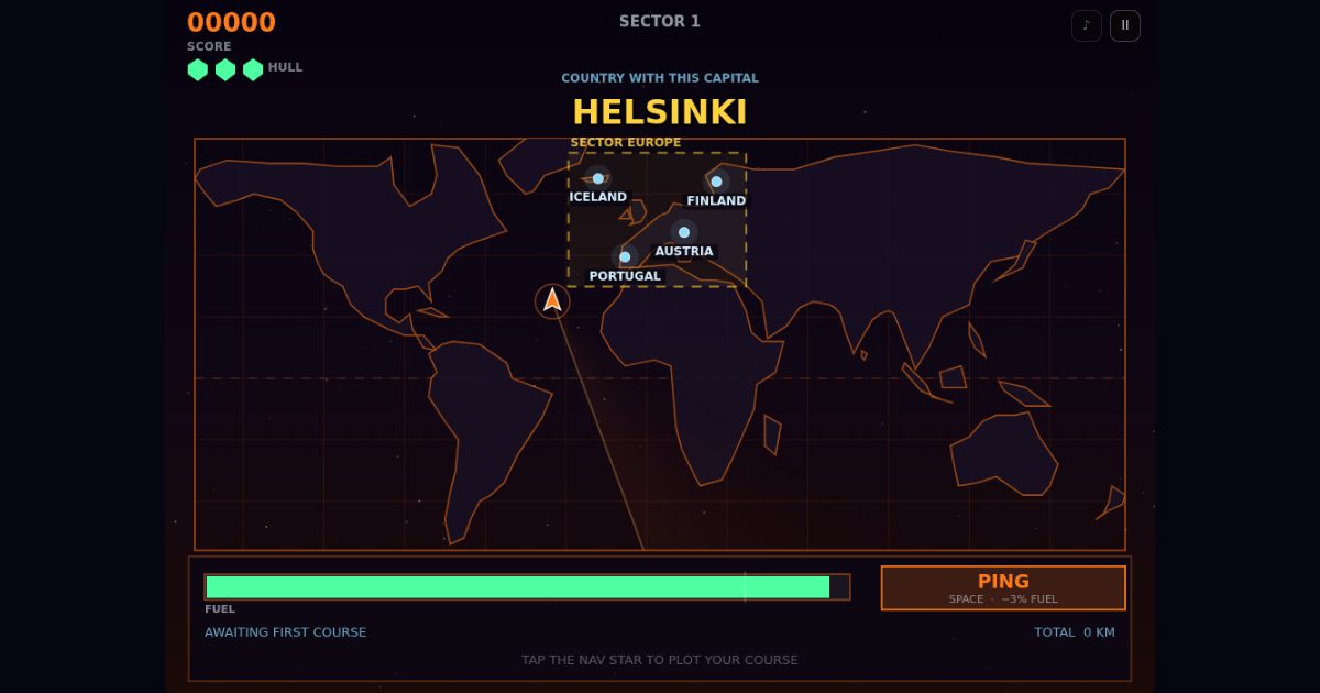
Your own mix, one link for the class
The link opens Star Charts with just that mix. Saved settings on a student's computer are left alone.
Countries: PLOT COURSE TO PERU: find the country on the map. Capital cities: COUNTRY WITH THIS CAPITAL: LIMA: find the country whose capital it is. Continents: TAP ANY COUNTRY IN SOUTH AMERICA: needs two or more continents in play. Landmarks: COUNTRY WITH THIS LANDMARK: MACHU PICCHU: find the country it is in.
Names on the map: Learning the map: every country dot is labelled. No names (map quiz): Find it from where it sits; a ping (costs fuel) shows the names for a moment. By speed tier: Names on at Rookie, Cadet and Pilot; at Ace they light up only as the scanner sweeps past.
More free games
Every game on the Arcade Deck is free, with no account.
- Meteor MathTimes tables: type the answer before the meteor lands.
- Word WarpSpelling: the word flashes on the warp gate, then type it from memory.
- Cell DiveCell biology: steer into the organelle that does the job named.
- Atom SmashThe periodic table: smash the element the panel names.
- Geo Storm2D shapes: patch the hull with the matching plate.
- Code BreakerLogic: crack a secret shape code from the lock's clues.
See all 12 free games · 2D shapes game · Fractions game · Times tables game · Spelling list game
Questions teachers ask
- Is it free?
- Yes. Star Charts is one of the 12 games on the Arcade Deck, which is free to play with no account and nothing to install. The ten rooms on the Promenade are for members; nothing on this page needs one.
- What do students need?
- A desktop or laptop computer with a mouse or trackpad (click a star to plot the course) and an up-to-date browser.
- Which countries are in it?
- 74 countries on six continents, each with its capital city, and 30 famous landmarks. That is not every country in the world: the chart keeps the ones a grade 3-6 class meets first, and each continent card above lists exactly which ones are in. There is no Antarctica, no oceans, and no states, provinces or rivers.
- How are Russia, Turkey and Kazakhstan handled?
- They sit in both Europe and Asia, so the game puts them on the Asia chart and never makes one of them the answer to "tap any country in Europe" or "...in Asia". They can still come up by name, capital or landmark.
- Can I pick the continents and questions?
- Yes. Tick the continents, the question types and the map names in the picker above and you get one link that opens Star Charts with that mix. The mix lives in the link itself; we do not store anything.
- Does it go too fast for younger students?
- It opens on Rookie, the slowest setting, with eight stars on the chart, names on, the continent box shown and a relaxed fuel tank. Teacher Setup in the game changes the speed and turns the after-a-miss lesson on or off.
- Do students sign in, or does it collect anything?
- No sign-in and no student accounts. There are no ad trackers. See the privacy page for the details. Privacy.
- Who makes Starship Arcade?
- Starship Arcade is a small independent studio in Ontario. The games are built with AI and tested before they ship.